Products
3D POI SDK
key use cases and case studies
3D POI SDK in Action
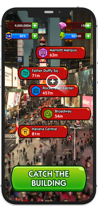
Gamifying data collection
Users are catching the building and improve POI information in mini-game instead of monotonous surveys.
We are developing AABB-based occlusion detection methods in three-dimensional space.
The user's position and direction in 3D space are obtained from sensors in the device - GPS, accelerometer, & compass.
We are developing AABB-based occlusion detection methods in three-dimensional space.
The user's position and direction in 3D space are obtained from sensors in the device - GPS, accelerometer, & compass.
POI data integrity
Data obtained from users is validated and cleaned with usage of machine learning algorithms that calculate their scoring.
This process ensures constant update and quality improvement of the database with over 100M POIs without outliers or fake data.
This process ensures constant update and quality improvement of the database with over 100M POIs without outliers or fake data.
AR display aligned with real world
Icons displayed in AR based on gps coordinates, height of the building, land elevation, gyroscope, compass supported with occlusion algorithm ensures clean display of the information about POIs
Personalised POIs for users
Reality AR connected with Big Dots engine ensures data personalisation on different layers such as:
+1000 POI categories
Gdp data
Light pollution
Crime rate
Unemployment rate
POI rating
Checkins
Review count
+1000 POI categories
Gdp data
Light pollution
Crime rate
Unemployment rate
POI rating
Checkins
Review count


Product information
3D POI unlocked

Optimized Data Transfer
Go beyond radius and polygon by using a combination of GPS, Cell, Wifi, Bluetooth, Accelerometer and time-of-day data.

Open Street Map dataset
Compliment precise snap-to-place technology with flexible geofences.

Mall mode
Precise visits captured in larger venues with enclosed POI, such as malls and airports.


Products
Reality Maps
key use cases and case studies
Reality Maps in action
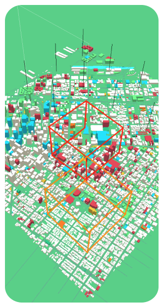
3D rendered environment for Unity game engine
buildings with 2D multipolygon shape extruded to a 3D volume with accurate height roads and rivers system based on curves with variable width landuse areas such as lakes, forests, fields rendered as 2D planes
Aggregation of POIs into building objects
buildings will retain the information about all the POI objects that are located inside their area and allow the user to retrieve it
Extensive metadata available for all rendered objects
Buildings expose information about height (in meters) or number of floors, generalized information about the materials used for construction and names in multiple languages
Roads include the general type information ranging from pedestrian walking paths, through alleys and one lane roads up to multi-lane highways as well as information about the surface type of the road and if the road is one- or two-way
Roads include the general type information ranging from pedestrian walking paths, through alleys and one lane roads up to multi-lane highways as well as information about the surface type of the road and if the road is one- or two-way
Optimized rendering for high density city
Optimized data transfer between client and server using Google’s open source flat buffers serialization library instead of JSON payloads - this enables highly compressed map data transfer with blazing fast runtime efficiency for both client and server
Smart map sharding algorithm
Smart map sharding algorithm that downloads the map data starting with the shard that is shown to the user in the center of the screen first and loading map shards not visible on the screen last

Product information
Reality Maps unlocked
Optimized Data Transfer
Go beyond radius and polygon by using a combination of GPS, Cell, Wifi, Bluetooth, Accelerometer and time-of-day data.
Open Street Map dataset
Compliment precise snap-to-place technology with flexible geofences.
Mall mode
Precise visits captured in larger venues with enclosed POI, such as malls and airports.